
We’re all hooked on navigation apps and can’t remember what life was like without‘em. For the direction challenged, apps that give you turn-by-turn instructions are saviors. Their up-to-date travel time estimates increase the predictability of commutes. Without a doubt, these apps reduce commuting stress and bring happier commutes. But, while their benefits are significant, they have also made driving easier.
The decision to drive usually makes sense when minimizing commute time is the key goal. But, if your goal is to maximize enjoyment during the trip (whatever that means for you), or minimize travel costs, the fastest option may not be the answer. Maybe you can allot 30 minutes to a trip, so getting there in 15 minutes is not necessarily ideal. Future navigation apps should be able to help commuters optimize their route based on multiple goals, not just travel time.
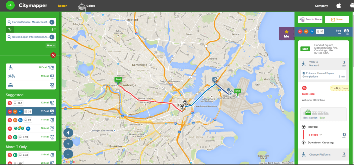
Citymapper is a new navigation app that gives commuters more travel suggestions, based not only on time, but also on calorie information. For those seeking to maximize calories burned, go for the walk! The firm’s stated focus is on public transit, walking and biking directions. Driving times and directions are available (the app also estimates the cost of an Uber), but driving is never the suggested option. While most navigation app make driving easier, this one focuses on helping users navigate most efficiently using public transit.
I compared Citymapper to Google Maps and can confirm that Citymapper provides way more public transit options. For example, getting from Harvard Square to Logan Airport resulted in five suggested public transit-based routes. By comparison, Google Maps provided one option only (the first one in the screen shot below). Personally, I prefer choice number two (Red Line, Orange Line, Blue Line, Bus 33).
Another option that is not available elsewhere is information on the location of bike sharing stations. In Boston, this would be Hubway bike stations. Users can locate stations and view how many bikes are still available for rental.
A recent addition to the app is multi-mode recommendations. On March 30, the firm announced recommendations that combine public transit and cabs. Providing mixed mode commuting options seems to align better with how city commuters actually travel. I know many Bostonians who drive to the commuter rail, park, ride, and then walk from the train station to their office.
Citymapper is growing rapidly and is always launching new features and functions. This is a firm that is addressing the urban mobility challenge head on and will be exciting to watch!
